

Construction projects today face tighter schedules, higher cost pressure, and greater coordination demands, making accurate site data critical during pre-construction planning. Incomplete or inaccurate existing condition documentation often leads to rework, delays, coordination conflicts, and increased project risk. While traditional surveying continues to support many projects, modern construction environments increasingly require faster and more detailed data capture.
This is why many firms are adopting 3D laser scanning and reality capture solutions. 3D laser scanning can reduce field data collection time by up to 50% compared to traditional manual surveying methods, particularly on large or coordination-intensive projects. RPG Squarefoot Solutions helps construction teams improve planning accuracy through advanced 3D laser scanning technologies and rental solutions. In this post, we compare traditional surveying and 3D laser scanning across cost, risk, and long-term ROI.
What is Traditional Surveying
Traditional surveying uses tools such as total stations, GPS equipment, and manual measurements to capture site data for construction planning and layout development. Surveyors collect specific measurement points and convert them into drawings, maps, or layouts used during design and construction.
Traditional surveying works well for:
- Boundary surveys
- Small construction projects
- Basic topographic mapping
- Simple layout verification
While effective for straightforward projects, traditional surveying can become time-consuming on complex sites where missing dimensions or incomplete documentation may lead to revisits and coordination issues.
What Is 3D Laser Scanning
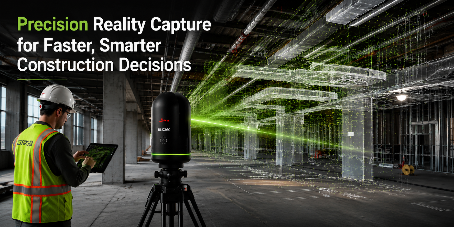
3D laser scanning uses LiDAR-based technology to digitally capture existing site conditions with high precision. Solutions such as the Leica BLK360 and Leica RTC360 collect millions of measurements and generate highly detailed point cloud data for analysis and modelling.
Unlike traditional surveying, 3D laser scanning captures complete site geometry instead of selected measurement points. The captured data can also integrate directly into BIM workflows through scan to BIM services, supporting design coordination, clash detection, and construction planning.
Construction teams commonly use 3D laser scanning for renovation projects, infrastructure construction, industrial facilities, and MEP coordination.
The Hidden Cost of Incomplete Site Data
The true cost of inaccurate surveying often appears later in the project lifecycle. Missing dimensions, undocumented conditions, and coordination gaps can lead to RFIs, schedule delays, fabrication issues, change orders, and field rework.
On coordination-intensive construction projects, even small documentation errors can create downstream impacts that affect budgets, timelines, and operational efficiency. Comprehensive reality capture helps reduce these risks by improving visibility before construction begins.
Traditional Surveying vs. 3D Laser Scanning: A Comparison
Below is a comparison of traditional surveying and 3D laser scanning across key project parameters.
|
Comparison Factor |
Traditional Surveying |
3D Laser Scanning |
|
Data Capture Method |
Selective point measurements |
Full digital site capture |
|
Capture Speed |
Slower manual workflow |
Rapid LiDAR-based scanning |
|
Site Coverage |
Limited measured points |
Millions of comprehensive data points |
|
Accuracy |
Dependent on manual measurements |
Millimeter-level precision |
|
Revisits |
More likely |
Significantly reduced |
|
Rework Risk |
Higher due to missing data |
Lower through complete documentation |
|
Coordination Efficiency |
Greater clash potential |
Improved BIM coordination |
|
Processing Workflow |
Manual drafting |
Digital point cloud processing |
|
Safety Exposure |
Requires physical access |
Remote capture improves safety |
|
Project Complexity Support |
Best for simple layouts |
Ideal for complex environments |
|
Long-Term ROI |
Lower lifecycle efficiency |
Higher operational ROI |
Better Site Data Leads to Better Project Outcomes
As construction projects become more complex and coordination-driven, the demand for accurate digital site data continues to grow. Modern reality capture workflows support better collaboration between architects, engineers, contractors, and facility teams by creating reliable digital representations of existing conditions. Through scan-to-BIM integration and advanced coordination workflows, 3D laser scanning has become an essential technology for improving project predictability, reducing operational risk, and supporting more efficient project delivery. Reduce Rework and Improve Project Accuracy with Advanced 3D Laser Scanning Solutions. Explore available 3D laser scanning and rental solutions to improve decision-making help teams avoid costly coordination issues and maintain tighter project control.
Frequently Asked Questions
- Is 3D laser scanning more accurate than traditional surveying?
Yes. 3D laser scanning captures millions of precise measurement points across the entire site, providing millimeter-level accuracy that reduces documentation gaps and coordination errors. - Does 3D laser scanning reduce construction costs?
While upfront costs may be higher, laser scanning can reduce total project costs by minimizing rework, reducing site revisits, improving coordination, and accelerating project timelines. - Can laser scanning integrate with BIM workflows?
Yes. Point cloud data captured through laser scanning can integrate into scan-to-BIM workflows, supporting clash detection, digital twins, as-built modeling, and construction coordination.
Blog Latest Posts
Construction projects today face tighter schedules, higher cost pressure, and greater coordination demands, making accurate site data critical during pre-construction planning. Incomplete or inaccurate existing condition documentation often leads to rework, delays, coordination conflicts, and increased project risk. While traditional surveying continues to support many projects, modern construction environments increasingly require faster and more detailed data capture.
This is why many firms are adopting 3D laser scanning and reality capture solutions. 3D laser scanning can reduce field data collection time by up to 50% compared to traditional manual surveying methods, particularly on large or coordination-intensive projects. RPG Squarefoot Solutions helps construction teams improve planning accuracy through advanced 3D laser scanning technologies and rental solutions. In this post, we compare traditional surveying and 3D laser scanning across cost, risk, and long-term ROI.
What is Traditional Surveying
Traditional surveying uses tools such as total stations, GPS equipment, and manual measurements to capture site data for construction planning and layout development. Surveyors collect specific measurement points and convert them into drawings, maps, or layouts used during design and construction.
Traditional surveying works well for:
- Boundary surveys
- Small construction projects
- Basic topographic mapping
- Simple layout verification
While effective for straightforward projects, traditional surveying can become time-consuming on complex sites where missing dimensions or incomplete documentation may lead to revisits and coordination issues.
What Is 3D Laser Scanning
3D laser scanning uses LiDAR-based technology to digitally capture existing site conditions with high precision. Solutions such as the Leica BLK360 and Leica RTC360 collect millions of measurements and generate highly detailed point cloud data for analysis and modelling.
Unlike traditional surveying, 3D laser scanning captures complete site geometry instead of selected measurement points. The captured data can also integrate directly into BIM workflows through scan to BIM services, supporting design coordination, clash detection, and construction planning.
Construction teams commonly use 3D laser scanning for renovation projects, infrastructure construction, industrial facilities, and MEP coordination.
The Hidden Cost of Incomplete Site Data
The true cost of inaccurate surveying often appears later in the project lifecycle. Missing dimensions, undocumented conditions, and coordination gaps can lead to RFIs, schedule delays, fabrication issues, change orders, and field rework.
On coordination-intensive construction projects, even small documentation errors can create downstream impacts that affect budgets, timelines, and operational efficiency. Comprehensive reality capture helps reduce these risks by improving visibility before construction begins.
Traditional Surveying vs. 3D Laser Scanning: A Comparison
Below is a comparison of traditional surveying and 3D laser scanning across key project parameters.
|
Comparison Factor |
Traditional Surveying |
3D Laser Scanning |
|
Data Capture Method |
Selective point measurements |
Full digital site capture |
|
Capture Speed |
Slower manual workflow |
Rapid LiDAR-based scanning |
|
Site Coverage |
Limited measured points |
Millions of comprehensive data points |
|
Accuracy |
Dependent on manual measurements |
Millimeter-level precision |
|
Revisits |
More likely |
Significantly reduced |
|
Rework Risk |
Higher due to missing data |
Lower through complete documentation |
|
Coordination Efficiency |
Greater clash potential |
Improved BIM coordination |
|
Processing Workflow |
Manual drafting |
Digital point cloud processing |
|
Safety Exposure |
Requires physical access |
Remote capture improves safety |
|
Project Complexity Support |
Best for simple layouts |
Ideal for complex environments |
|
Long-Term ROI |
Lower lifecycle efficiency |
Higher operational ROI |
Better Site Data Leads to Better Project Outcomes
As construction projects become more complex and coordination-driven, the demand for accurate digital site data continues to grow. Modern reality capture workflows support better collaboration between architects, engineers, contractors, and facility teams by creating reliable digital representations of existing conditions. Through scan-to-BIM integration and advanced coordination workflows, 3D laser scanning has become an essential technology for improving project predictability, reducing operational risk, and supporting more efficient project delivery. Reduce Rework and Improve Project Accuracy with Advanced 3D Laser Scanning Solutions. Explore available 3D laser scanning and rental solutions to improve decision-making help teams avoid costly coordination issues and maintain tighter project control.
Frequently Asked Questions
- Is 3D laser scanning more accurate than traditional surveying?
Yes. 3D laser scanning captures millions of precise measurement points across the entire site, providing millimeter-level accuracy that reduces documentation gaps and coordination errors. - Does 3D laser scanning reduce construction costs?
While upfront costs may be higher, laser scanning can reduce total project costs by minimizing rework, reducing site revisits, improving coordination, and accelerating project timelines. - Can laser scanning integrate with BIM workflows?
Yes. Point cloud data captured through laser scanning can integrate into scan-to-BIM workflows, supporting clash detection, digital twins, as-built modeling, and construction coordination.